In the summer of 1894, Jose Vicente DeLaveaga attended a meeting where Santa Cruz city leaders aired their hopes of one day building a city park with a baseball field and picnic areas. A lifelong bachelor and loner who had come to Alta California as the child of aristocrats during the Gold Rush and prospered in finance, DeLaveaga had developed a love of nature, gardening, winemaking, and all things bucolic after moving to Santa Cruz in his twenties. He had also, it seemed, imbibed the aristocratic notion of noblesse oblige, or helping those less fortunate.
When DeLaveaga fell ill and died two months later, just shy of his 50th birthday, people were stunned to learn that he had left his 640-acre hilltop estate to the City and County of Santa Cruz for a park, along with a $125,000 trust fund to build a home for the elderly and disabled and an estimated $2 million to charity. The family challenged the will, and the city never got the trust fund, but it now had the makings of an incredible park.
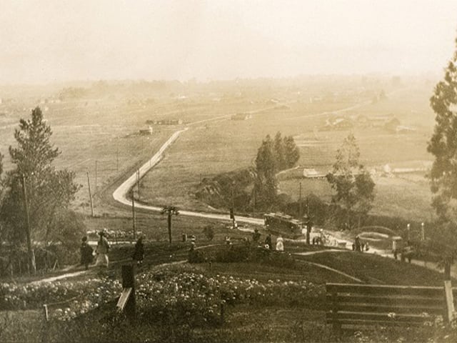
Then, as now, the park’s hilltop perch offered spectacular views of the countryside and Monterey Bay, but it had almost no infrastructure and was hard to find. That quickly changed over the next few years. By 1910, landowner Patrick Morrissey had widened the road to the park and constructed a grand entry with stone gateposts, streetlights, an archway, and rowboats planted with colorful flowers, while one of the founders of the electric company PG&E electrified a trolley line running all the way to the entrance.
By this time the park had a duck pond and a race track, and in 1911 it got its baseball field thanks to the Odd Fellows. Not to be outdone, the Saturday Afternoon Women’s Club funded and built a rustic Rose Pergola and tea house on the hill overlooking the grand entrance in 1912.
The park grew in popularity as a destination for families looking to relax and take in the views of the Bay. Soon the park even had a zoo with a small herd of tule elk, bison, bears, peacocks, and monkeys. Historian Eric Ross Gibson, in his fascinating history of the park, describes a scene where the silent film star Mary Pickford hand-feeds caramels to one of the park’s gentle bears, which had been selected to appear in one of her movies.
When the trolley tracks were torn up in 1926, park attendance fell off. The zoo closed during the Great Depression, and in the late 1940s a Navy training center was built on the property and the grand entry closed. The park lost its luster and popularity. It wasn’t until 1960 that help arrived in the form of a park master plan that included such public benefits as a shooting range and a golf course.
In 1970 an 18-hole championship golf course designed by course architect Bert Stamps opened as the park’s crowning glory. The city-owned DeLaveaga Golf Course offered a reasonably priced alternative to some of the spendier links found around Monterey Bay and featured the stylish DeLaveaga Lodge restaurant, which overlooked the course and served up “good food, man-sized drinks, and a cordial atmosphere,” according to one 1972 magazine article. The course’s first head golf pro was Gary Loustalot, whose son Tim Loustalot, along with his wife Jamie, now runs the golf concession along with the newly redesigned restaurant, the Grille at DeLaveaga.
In the 1980s, a disc golf course opened at the park. Designed by legendary disc golfer Tom Schot, DeLaveaga Disc Golf Course, affectionately known as “DeLa,” is regarded as one of the best courses in the world and hosts the World Championship every year. The course is located in Upper DeLaveaga Wilderness Park, a pine and oak tree-covered ridgeline that overlooks the Monterey Bay, with expansive ocean views including the most famous: “Top of the World” (Hole 27).
Today, the park is also home to a network of hiking and mountain biking trails, as well as the Santa Cruz Shakespeare Festival held each summer at the Audrey Stanley Grove overlooking the bay. DeLaveaga Park features two softball fields, two bocce ball courts, a sand volleyball court, horseshoe pits, a children’s playground, picnic areas, and a large turf area called The Meadow. An Archery Range offers a course consisting of two one-way trails (14 targets on each), 28 outdoor field targets, and a practice range with five targets huts.
A nostalgic look back at the West Coast’s oldest amusement park
Since its opening in 1907 as the “Coney Island of the West,” the Santa Cruz Beach Boardwalk has been the backdrop for scores of noteworthy cultural events through the years, from Duke Kahanamoku’s historic 1913 surfing exhibit to the Miss California pageant to major motion pictures, including Lost Boys and the Dirty Harry vehicle Sudden Impact.
Read on to learn about these historical nuggets from yesteryear at this iconic seaside amusement park. If you are visiting the Boardwalk today, be sure to take the self-guided historical walking tour.
The history of the Boardwalk itself is equally lively, telling the tale of a growing seaside town and a freewheeling spirit of fun and innovation that powered the amusement park through the 20th century and into the 21st. We recently took a tour through some old photos and enjoyed them so much we thought we’d share.
From 1917 to 1968, you could always get a turnover pie at the Boardwalk. Flaky pastry wrapped around chicken or maybe a nice warm huckleberry or apple filling made for an inexpensive snack (precisely 15 cents in 1933, when this picture was taken). Plus you could “See ‘em made”! And get buttermilk! So the thrills didn’t have to stop just because you got off the Giant Dipper.
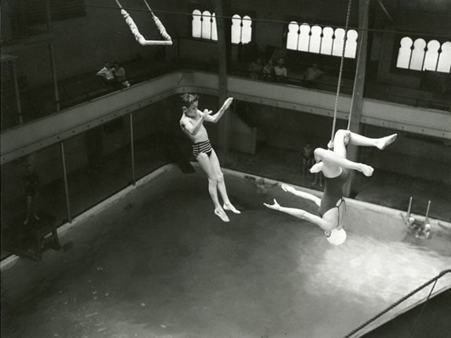
For almost 20 years, between 1927 and 1945, the Boardwalk staged Water Carnivals in the Plunge, the heated saltwater natatorium built-in 1907. Pictured in this 1941 photo are young Fred Quadros, Jr. and Shirley Wightman, an “aquabrat” and “aquabelle” (as carnival kids were affectionately known) who thrilled audiences with their aerial feats of derring-do.
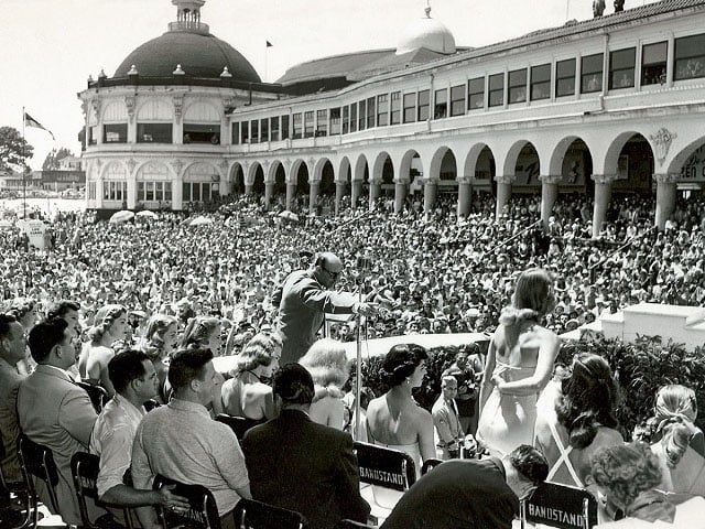
The Miss California contest was held at the Boardwalk every year between 1924 and 1966. In this 1951 photo, the contestants are seated on the dais waiting their turns to answer the judges’ questions. The contest eventually moved to downtown Santa Cruz until protesters shut it down in 1985. Today it’s held in Fresno.
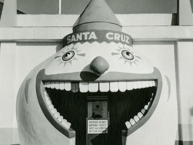
The Palace of Fun, with its goofy mirrors, giant slide, rotating barrel, and hijinks galore, opened in 1925, but it wasn’t until the 1940s that the famous clown mouth entrance to the Fun House appeared. Inside the funny man’s grinning gullet, on the ticket booth, is a sign informing patrons of a strict rule: no wet bathing suits allowed inside.
In this 1958 publicity shoot for Southern Pacific, models navigate the rotating barrel of the Fun House as a crowd looks on.
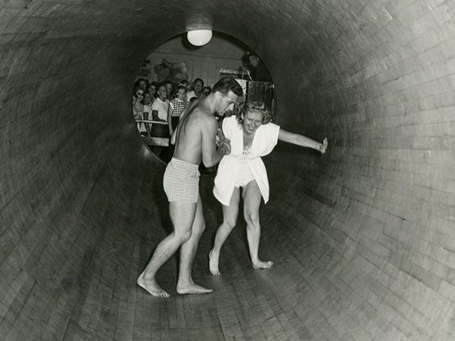
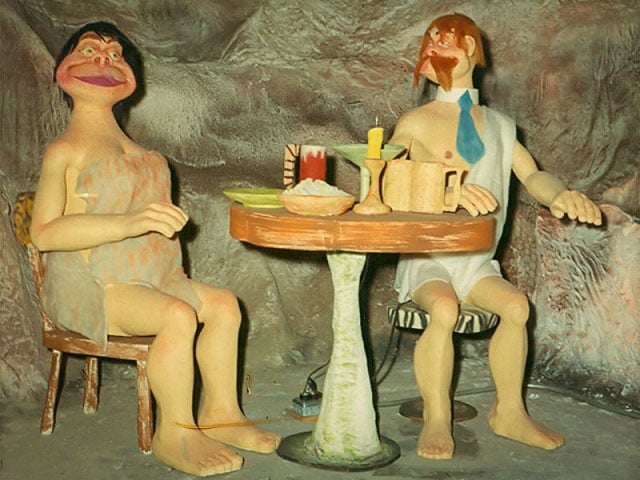
This handsome couple enjoyed dinner, drinks, and the jazzy strains of “Bei Mir Bist Du Schoen” from 1962 until 1998 as part of the campy Cave Train to the Lost World. While goofy dinosaurs hatched and menaced riders on the train, their fellow cavepeople cheated at cards, tried to open boxes of dynamite, and otherwise created mayhem to the delight of Boardwalk visitors during those happy decades.
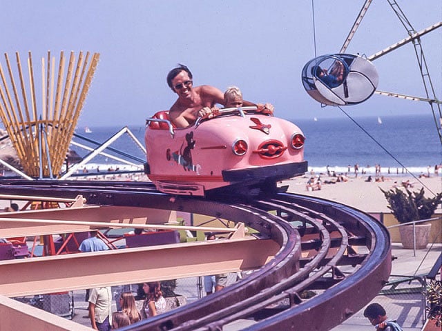
In 1958 the Boardwalk opened the Wild Mouse, a small but mighty German-made roller coaster with a reputation that dwarfed its cute little two-passenger cars. With unbanked 90-degree turns, quick drops, and rapid-fire zig-zags, the Wild Mouse was untamed indeed. In 1975 it was removed to make way for the Logger’s Revenge, the classic log flume ride.
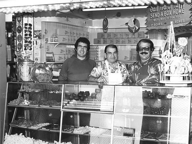
In 1980, Marini’s had already been on the job making and selling saltwater taffy at the Boardwalk for 65 years. In this photo, Joe Jr., Joe Sr., and Joel Marini show off their sweet inventory.
The Boardwalk is still making history. Find out what’s new and start planning your next visit on our Boardwalk page. As the Boardwalk’s old slogan promises, it’s “never a dull moment!”
Mission Street circa 1880 shot roughly from the area where London Nelson had lived and farmed two decades earlier, looking up toward Mission Hill. The handsome white building in the upper left is the Mission School, built in part with proceeds from the rental of Nelson’s property. Photo courtesy of the Santa Cruz Museum of Art and History.
How a man born into slavery became one of Santa Cruz’s most famous philanthropists
It’s a quirk of Santa Cruz history that one of the town’s best-known benefactors was misidentified for decades on the signage of the community center and plaza that bear his name. Less well known is the story of how London Nelson, born into slavery in North Carolina in 1800, came to be a free man living in Santa Cruz who bequeathed all his worldly possessions to the town school district upon his death.
Details of London Nelson’s life are scant, and not a photograph or likeness remains. But a portrait emerges from historical accounts of a smart and resourceful man who was trusted and liked by adults and children alike, and who quickly joined in community and commercial life in his adopted town, going door-to-door selling produce grown on a plot by the river near what is now Downtown Santa Cruz.
TRAVELS WITH LONDON
London reportedly came to California in the Gold Rush year of 1850 with slaveholder Matthew Nelson and another enslaved man, a 26-year-old blacksmith named Marlborough. (Many of the enslaved Nelsons were named for European cities: Paris, Cambridge, Marlborough, etc.) The Nelson party worked a gold claim on the American River over the winter of 1850-51.
For London and Marlborough, the stakes could not have been higher: the chance to buy their freedom. Apparently, the trio struck gold, because a freed Marlborough accompanied Matthew back East a couple of years later, and London, now in his early fifties, began his life as a freed man in California by investing in cobblers’ tools and traveling around the new state repairing boots and shoes.
It’s impossible to say why London chose to settle down in Santa Cruz when he visited in 1856. He became one of two Black residents, according to one account, so it wasn’t a vibrant Black community that drew him. One factor may have been that Santa Cruz was a tolerant place by the standards of the time. The local Methodist Church, which was home to a group of Abolitionists, played an important role in the town’s civic life by doubling as a school during the week. Perhaps London took stock of this situation and decided the town was a good bet.
COMMUNITY LIFE
In any event, London settled in town, leased a cabin and a 6-acre plot of land near the river where he grew onions, potatoes, and watermelons, and sold his produce from a borrowed wagon pulled by a borrowed horse.
He also joined the Methodist Church, so he was likely aware when, in 1857, the rapidly growing church located a site for a two-room schoolhouse just up the hill from his own leased land. Kids on their way to the new Mission Hill School would cross the river near London’s place. They got to know “Old Man Nelson,” and he got to know them. In 1858 the school closed due to debt, and though it reopened the next year, the closure and its effect on the kids must have made an impression on London. Over the next couple of years, London continued to work even as his health declined. One day in April of 1860, the kids he had befriended ran to tell the town doctor that London had fallen severely ill. As he lay on his deathbed a few weeks later, he left his estate — $372 including the 6 acres, which he had purchased earlier that spring — to the school district. His was one of the first graves at Evergreen Cemetery.
SETTING THE RECORD STRAIGHT
So how did this remarkable man wind up misnamed in the historical record? The answer is surprisingly mundane.
Handwriting in the 19th century was florid and fancy, with flourishes galore. And people then, as now, sometimes made mistakes, had poor eyesight, or were sloppy. After London’s death, his name began showing up in the record as “Louden” Nelson. Or “Lindon” Nelson. Or London “Neilson.” Or, strangest of all, “Shannon” Nelson. By 1890, when students at Mission Hill School — by then a four-story Italianate building, thanks in part to district income from London’s property — decided to replace the weathered wooden headstone with a lovely new marble one, the reference they looked to spell the name “Louden Nelson.” The mistake was literally etched in stone. It was then repeated many times, including in 1979, when a new community center was named for him.
The name “London” hung around, though, like a rumor, spurring speculation and research that showed that his name had, in fact, been “London.” In the summer of 2020, in the aftermath of George Floyd’s death, Brittnii Potter of Santa Cruz spearheaded a movement to correct the record and have London’s name spelled correctly on the buildings and plaques that bear his name. In June 2021 the Santa Cruz City Council voted unanimously to rename them “London Nelson,” at last correcting a wrong that had stood for far too long.
Thanks to local historians Geoffrey Dunn and Ross Gibson for their well-researched articles on this topic, and to Santa Cruz Patch for its reporting.
Find more Santa Cruz local history about local landmarks and communities past here.
Outdoor activities and a vibrant community life make Santa Cruz County a natural destination when you’re flying solo.
When you’re ready for some adventuring on your own, Santa Cruz County offers a host of fun options in the great outdoors, from beach cruising to exploring the redwood forest. After an action-packed day, the laid-back ethos and bustle of the business districts make it easy to hang out and get a feel for a place so famous it has its own logo.
Any ultimate beach town experience, solo or otherwise, begins with waking up near the water so you can take in the serenity of morning by the sea. The Sea and Sand Inn and the West Cliff Inn make great places to start the day since you can step out the door and take a walk on West Cliff Drive to enjoy awe-inspiring views of Monterey Bay. Grab a cup of coffee at Steamer Lane Supply and watch the local surfers ply the world-famous waves of Steamer Lane, then pop into the tiny Santa Cruz Surfing Museum for a gander at riveting historic photos of Gidget-era surf culture in the beach town that started it all.
An afternoon of shopping and museum going in downtown Santa Cruz offers plenty of variety. Browse an eclectic collection of home goods, apparel and gifts at Stripe, then check in at Berdels to experience Santa Cruz style. For lunch on Pacific Avenue, stop by Abbott Square for a collection of tantalizing choices.
Farther up Pacific Avenue, Bookshop Santa Cruz is the city’s beloved well-lighted place for books. Browsing, and even sitting and reading for a spell, are welcome here, and Bookshop stocks a robust section on local history for the curious. Ready for an afternoon pick-me-up? A few steps away, Lulu Carpenter’s and Verve offer local coffeehouse experiences and unparalleled people-watching from their comfortable patios.
Down a side street off Pacific Avenue, find Abbott Square and the Museum of Art and History, where you can catch up on the history of Santa Cruz in the Santa Cruz County History Gallery and check out innovative art exhibits and community experiences like Frequency: Festival of Light, Sound and Digital Culture. Afterward, the gourmet Abbott Square Marketplace offers an intriguing selection of cuisines, from vegan to burgers, in an open-air setting that fills with convivial locals on weekends and evenings. Check the Abbott Square Marketplace page on Facebook for information on live music and other events under the stars (remember to bring a jacket—Santa Cruz evenings can be chilly).
For a different kind of adventure, start the morning renting a traditional or electric mountain bike or cruiser from Epicenter Cycling. (The Aptos location is just outside the entrance to Forest of Nisene Marks State Park, a popular local mountain biking destination.) Renting a cruiser from the Westside location for a day of tooling along the coast from Santa Cruz to Capitola is a fabulous way to see the local sights, including the Santa Cruz Harbor and the slice of surf town nostalgia known as Pleasure Point. If it’s a Sunday, save your morning appetite for the Live Oak Farmers Market, a year-round affair featuring local produce, food trucks, coffee and pastries.
Capitola itself is a postcard-perfect seaside hamlet of warrenlike streets lined with shops and eateries. Do some exploring, then climb the Depot Hill Steps (all 86 of them!) for a good look across Monterey Bay and a peek into one of the area’s oldest and most charming neighborhoods. Afterward, head to Gayle’s Bakery and Rosticceria, a county institution since 1978, for an excellent sandwich or salad and one of the spectacular desserts (the berry tartlette is always a pleaser).
For more outdoor fun, explore Santa Cruz County’s famed redwood forests on a hike. We recommend Henry Cowell Redwoods State Park for its loop of magnificent old-growth redwoods (keep an eye out for the small albino redwood, an intriguing anomaly) and an extremely rare ecosystem known as the Santa Cruz Sandhills. Henry Cowell is also a wonderful introduction to the old logging town of Felton, which boasts a small but lively commercial district that has undergone a renaissance in recent years.
Maybe you want to up your adrenaline quotient on this trip with a surf lesson, rock-climbing excursion or mountain bike ride. The professional guides at Adventure Out have you covered, and the group setting makes for extra fun. You can always relax tired muscles later with a spa treatment and poolside rejuvenation at picturesque Chaminade Resort & Spa. Or opt for a facial, massage, or acupuncture (and more!) at the downtown gem, Yoso Wellness Spa. Their holistic approach with “True Care from Skin to Soul” is poured into all of their treatments and offerings.
After all, this is your vacation—you can do it any way you want.
One of the prettiest ways to get from downtown Santa Cruz to sprawling, redwood-shaded San Lorenzo Park is to take the short stroll across the San Lorenzo River via the Chinatown Bridge. This scenic pedestrian walkway offers a great view of waterfowl and other bird life in the willows and reeds of the riverbanks, but it offers something else, too – a window into an intriguing chapter of Santa Cruz history. Like the eye-catching sculpted Dragon Archway that welcomes pedestrians to the bridge, this chapter is colorful, a little enigmatic, and steeped in the culture of the Chinese immigrants who helped shape the Golden State into what it is today.
Stand with the Dragon Archway at your back looking toward downtown Santa Cruz, and you’ll see a peaceful office complex with a pebbled walkway meandering through. This is the site of Santa Cruz’s last Chinatown. Now imagine that the levees behind you don’t exist, and in their place are river shallows blurring into a sloping floodplain. Closest to the water you see garden plots and wooden shacks on stilts; farther up the lane, on higher ground, ramshackle wooden houses line the road in sharp contrast to the grander buildings of the downtown business district looming beyond.
This is Birkenseer’s Chinatown, named after the landlord who rented to Chinese residents and merchants after an 1894 fire drove them from their settlement a few hundred yards north. In his excellent research on this topic, local historian Geoffrey Dunn explains that there had been other Chinatowns in Santa Cruz starting in 1859, their mostly male residents having emigrated from China in the Gold Rush. As recently as 1890 the county had claimed a population of 785 Chinese living in small settlements from Davenport to Watsonville, fishing, growing produce, working on railroads, operating laundries, selling Chinese herbs and goods, and working as cooks and servants.
As anti-Chinese sentiment swept across California in the late 1800s, Chinese communities were forced into an increasingly tenuous existence at the margins of the legal economy. After the 1906 earthquake, many of the Chinese residents of Santa Cruz returned to San Francisco and the relative security and prosperity of the established Chinatown there, leaving the small but colorful Birkenseer’s Chinatown behind. During the 1920s and 30s, the gambling halls, bordellos and opium dens of Santa Cruz’s Chinatown drew thrill-seekers and partiers from around the region, and though families and legitimate businesses thrived there, it was known primarily in the public imagination as a red-light district.
In time the population of Birkenseer’s Chinatown dwindled as people moved away and older bachelors passed on. Chinese men in California had always vastly outnumbered Chinese women, and that was especially true in Santa Cruz County, which held the dubious distinction of having the most unbalanced ratio of Chinese men to women in the state; it was challenging for the population to sustain itself.
George Ow and his uncle, Ah Fook, taken by George Lee and is featured on the cover of his book, Chinatown Dream
By 1955, just four households remained in Santa Cruz’s Chinatown. On the night of Dec. 22, 1955, after weeks of heavy rain across the entire state, the San Lorenzo River overflowed its banks and inundated downtown in a historic breach known as the Christmas Flood of 1955. Dunn describes the destruction as related to him by Santa Cruz businessman George Ow, who grew up in Chinatown. As redwood trees, cars and parts of houses swept past on the wild muddied river, Chinatown and its history were carried away too, chunk by chunk.
Four years later the Army Corps of Engineers embarked on a huge flood control project in Santa Cruz, and the city redeveloped the site where the old Chinatown once stood, forever burying it from view. The Dragon Archway, with its brilliantly hued tile mosaic water dragon and its graceful arch festooned with lanterns and poetry, stands as a reminder that beneath the surface of our modern cityscape lie layers and layers of stories and cultures ready to be rediscovered.
George Ow remembers his family history, part of the Santa Cruz Museum of Art & History’s exhibit Guided by Ghosts.
Resilience of Big Basin Redwoods State Park: Even 2020 can’t defeat a forest that has survived ice ages, wildfires and logging sprees
People the world over are looking to 2021 to be a year of healing — from division, disease and, here in California, a devastating wildfire season. Nowhere is that truer than in Santa Cruz County, where five blazes ignited by a dry lightning storm on the morning of August 16 tore through the mountains, destroying nearly 1,500 structures and burning more than 86,000 acres. Nearly all 18,000 acres of the beloved Big Basin Redwood State Park were scorched in what came to be known as the CZU August Lightning Complex Fire, including the park’s precious 4,400 acres of old-growth redwoods and the park’s headquarters built in 1936, which burned to ash along with almost all the other buildings on day two of the fire.
Upon news that the park had burned, social media lit up with messages of sorrow and remembrance from redwood lovers across the country. Big Basin, people were saying, was gone forever. A terrible loss had occurred, and we would have to learn to live without the beauty of California’s first state park.
But the eulogies for Big Basin’s redwoods were premature. Two months later — the very next breath, in Mother Nature years — tiny green sprouts had burst into sight throughout the forest. Along the redwoods’ huge blackened trunks and exposed roots, tender shoots started coming up, no bigger than moss at first but destined, some of them, to become enormous branches or maybe even big trees themselves someday, should the parent tree not survive. (Scientists have predicted that 10% of the old growth trees in the park will perish as a result of damages sustained from the fire, leaving 90 percent to carry on, battle-scarred but alive.)
Anyone who has wandered through a redwood forest knows what a fairy ring looks like: a circle of redwoods growing around the ghost of a massive mother redwood that fell long ago, whether from age or fire or the saw. These younger trees come into being through “basal sprouting,” the term for when shoots come up from a tree’s root system, typically as a result of stress. Basal sprouting is common among broadleaf trees but exceedingly rare among conifers, and it’s one of the secrets to redwood forest survival. Redwood sprouts can grow up to 7 feet in a single year in a sprint toward the sunlight, rapidly rebuilding the forest after loss. What’s growing right now in Big Basin, through the process of basal sprouting, are the fairy rings of the future.
Joanne Kerbavaz, senior environmental scientist with California State Parks, notes that the sad fate of the park’s historic buildings stands in sharp contrast to the resilience of the natural resources. Many of the park’s iconic named trees, including the “Father” and “Mother of the Forest,” have survived even though nearby infrastructure went up in flames. “Redwoods are incredibly resistant to fire and resilient to the effects of fire, and we’re seeing that play out in Big Basin,” she says. “I can’t help but focus on a hopeful outcome with the forest system.”
Built for Survival
First appearing in the fossil record across the Northern Hemisphere during the Jurassic Period (180-135 million years ago), redwoods began retreating from their vast ancient territory as the planet grew cooler and drier. Since the last ice age, their home has been a 450-mile strip of coastal Northern California and Southern Oregon that provides the moist, temperate climate they need to survive.
The indigenous people of California knew the redwood forests well. They used fire to shape the landscape, burning parts of redwood forests to encourage the growth of tanoak, which had the best acorns, and creating meadows to attract deer and certain plants. Between planned fires and lightning strikes, scientists estimate that some 4 million acres burned each year in California before Europeans arrived.
Redwoods had distinct advantages when it came to surviving these frequent fires: high water content, bark that can grow more than 12 inches thick, and tannin rather than flammable resin or pitch in their wood. Mature redwoods also have such high canopies that the crown seldom burns. These are the reasons most of the old-growth redwoods we see bear burn scars from fires nobody remembers: the fires scarred, but did not kill, the trees.
The European settlement of California brought logging to the ancient redwoods’ 2-million-acre domain. In the Santa Cruz Mountains, logging began in earnest in 1840 with the first mechanized sawmill and ramped up in 1880 with the steam donkey. By the turn of the century, 96% of the old-growth trees had been logged, with only oddly formed or inaccessible trees remaining, for the most part.
In May 1900, a party of civic-minded writers, scientists and citizens from San Jose and the Peninsula, concerned about rampant logging in the mountains, took a trip to see a grove of old-growth redwoods. Camped near Sempervirens Falls, they named themselves the Sempervirens Club and passed a hat to jump-start the purchase of the grove for protection. With help from the presidents of Stanford University and then-Santa Clara College, as well as the editor of the San Jose Mercury News, the Sempervirens Club persuaded the California legislature in 1901 to purchase 3,800 acres for the creation of the California Redwood Park, the state’s first. It was, of course, later to become Big Basin Redwoods State Park.
Recovery and Reopening
In the nearly 120 years since coming under the protection of the California state park system, the redwood forest of Big Basin has made a remarkable recovery from the assault by loggers. Many first-time visitors probably don’t even realize that they are looking at relatively young second-growth trees. Beloved trails like the Redwood Loop, the Sequoia Trail and the Skyline-to-the-Sea Trail lead past impressive redwoods and Douglas firs to beautiful forested vistas bearing no resemblance to the barren hillsides, slash, and drag marks left in the wake of uncontrolled logging.
Big Basin won’t be open to visitors for another year. Kerbavaz explains that there are just too many boardwalks, steps, handrails, culverts and bridges to be built before visitors can safely enter the park, and “hazard” trees must be felled so they don’t topple in high winds and wreak more havoc. Additionally, the natural resources need time to recover.
As a scientist, Kerbavaz is looking forward to seeing if more redwood seedlings than usual appear this spring, drinking in sunlight usually blocked by thick understory. She’s also eager to see what happens with knobcone pine trees, whose cones require temperatures of over 350 degrees open. “We expect to see a flush of new seedlings from those trees,” she says. Other than that, she notes, it’s hard to predict what the forest will look like in 5, 10, or 20 years.
“One thing we know is a high proportion of redwoods survive fires. One study showed that 95% of them survive,” she says. “They’re just going to look different for a while.”
Kerbavaz points out that in 1904, shortly after the state park designation, Big Basin suffered a fire that “devastated” the landscape, according to horrified witnesses. Today few people are even aware of that fire’s existence.
“We don’t have the data to look back on a regional scale and say, ‘Was there a fire like [the CZU fire] in the past?’ But I know with trees that stand for 2,000 years, they’ve seen a lot.”
Read more about the resilience of the Big Basin Redwoods State Park forest in Redwood Love.
Relics of the Spanish and Mexican eras, the county’s oldest buildings have fascinating stories to tell.
Driving through busy modern-day Santa Cruz County, it’s hard to imagine a time when the rolling hills ran down to the sea uninterrupted by houses, bridges, roads and office buildings. But of course that’s what the first Spanish settlers found when they marched up from Monterey to establish a mission in 1791. To build the Misión de la Exaltacion de la Santa Cruz, they used the materials at hand—timber, felled at great effort and expense, and dirt, plentiful and free.
Given the two choices, it’s easy to see how adobe, a mixture of earth and water bound by straw or manure, became the predominant building material not just in Santa Cruz but throughout Alta California, as Spain worked to establish a foothold here. Santa Cruz County is home to four historic adobes from the Spanish and Mexican periods (1769-1850). Their stories track California’s own complex history of settlement by waves of soldiers, priests, and finally civilians, all with their own versions of the California dream.
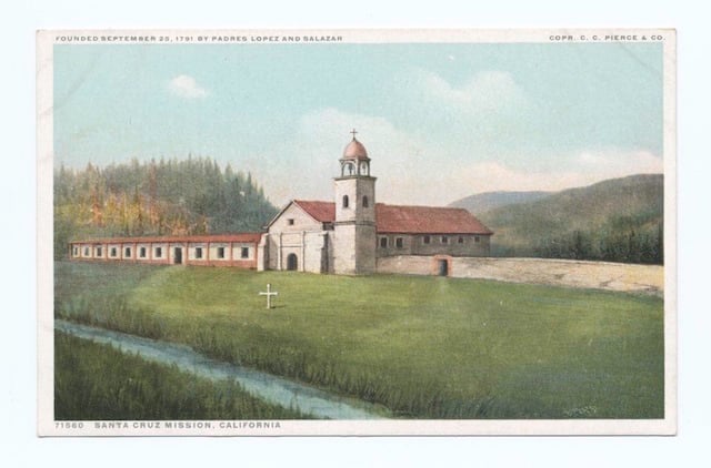
Postcard modeled after an 1853 painting of Mission Santa Cruz by Frenchman Leon Trousset. The long, low building at left resembles the style of the Mission Adobe, one of Santa Cruz County’s last remaining historic adobes.
The first European settlement in the area was the Santa Cruz Mission, built on the hill overlooking present-day downtown Santa Cruz. Established in 1791 by Spanish priests, it was the 12th of 21 missions meant to form the foundation of a Spanish-style society in California. The Ohlone-speaking indigenous people who lived at and near the mission labored in the fields and orchards, milled flour, and worked crafts and trades such as weaving, spinning, blacksmithing, and leather tanning.
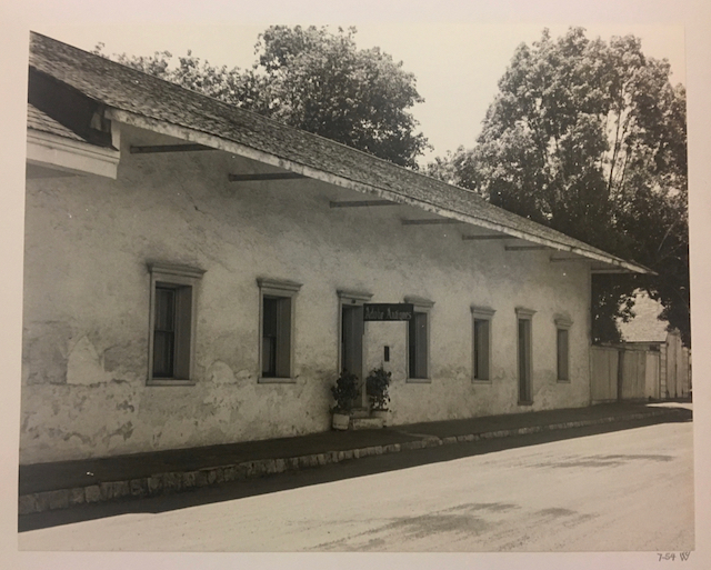
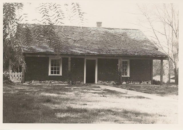
The Mission Adobe (also called the Neary-Rodriguez Adobe) as it was in 1954, when still occupied by residents and the Adobe Antiques shop. Photo by Van Court Warren, courtesy of the California State Library Historic Collection.
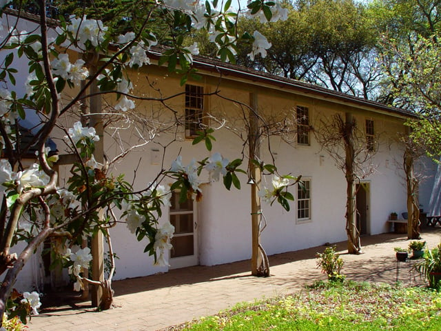
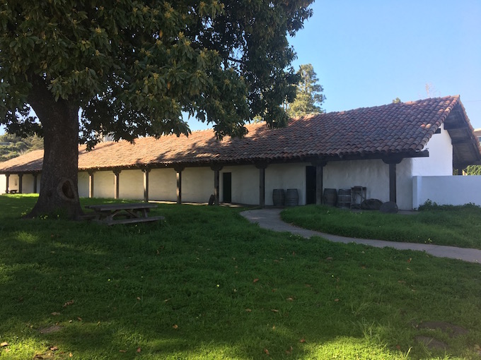
Today Mission Hill is the home of California’s only surviving example of mission housing for indigenous people. A kind of early apartment house, the Mission Adobe is a long, low-slung structure one room wide and seven rooms long (the original building had 17 rooms), with walls two feet thick in the classic adobe style. Built between 1822 and 1824, its construction mirrored that of a dormitory that stood across the creek (where School Street now runs). These dwellings housed indigenous artisans and craftspeople and their families.
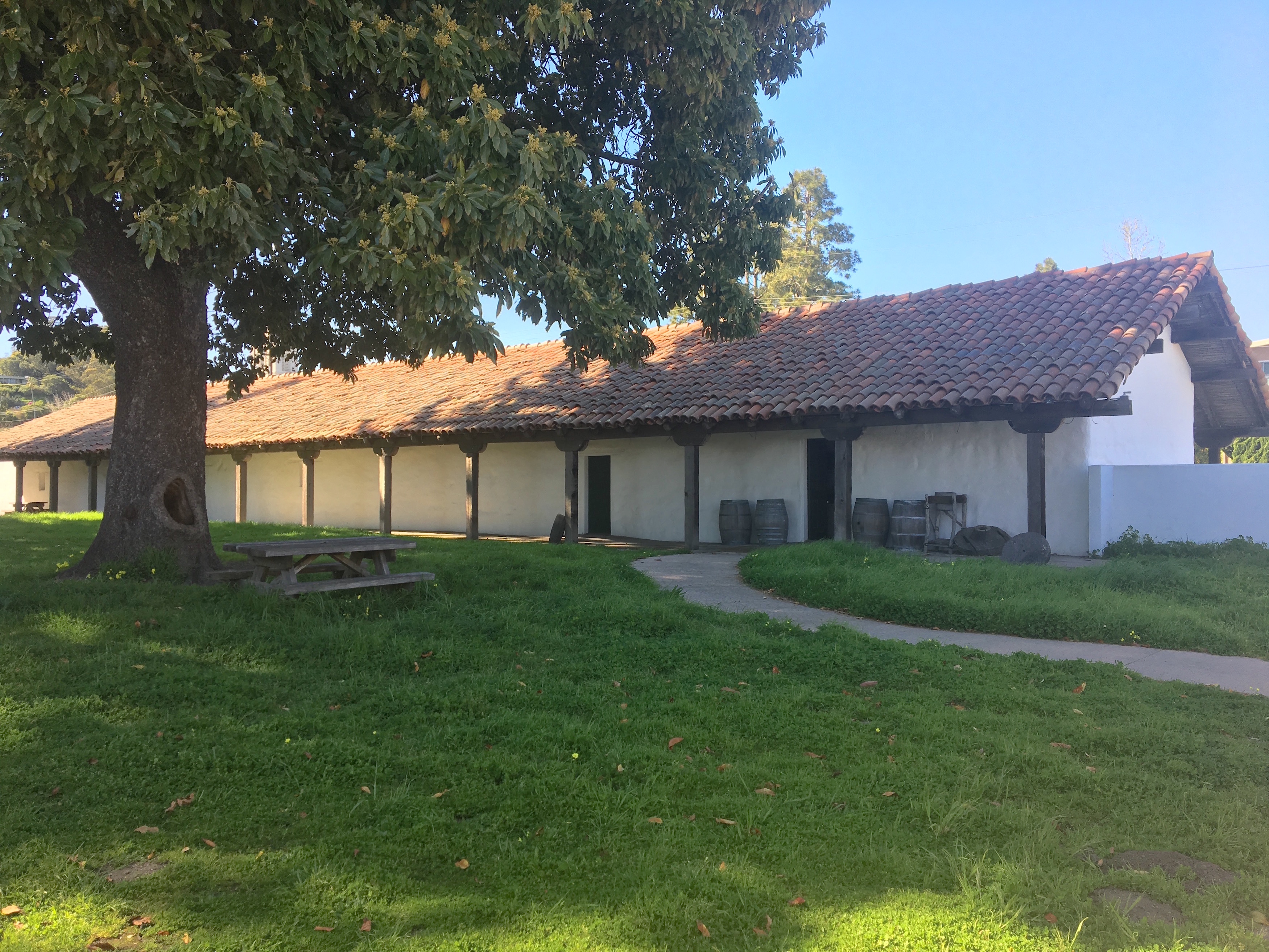
The Mission Adobe housed indigenous families during the Mission Era. It’s now a California state park. Traci Hukill photo.
Now the centerpiece of Santa Cruz Mission State Historic Park, the Mission Adobe contains a wealth of information about Ohlone lifeways, as well as the history of the adobe as it passed from generation to generation, miraculously surviving earthquakes and real estate booms. It’s all that remains of the mission complex that once sprawled across this bluff overlooking Monterey Bay. Fun fact: The avocado tree that stands in the courtyard is thought to be the second oldest in California.
The privately owned Branciforte Adobe in 1975. It is one of the few historic adobes in California thought to have been continuously inhabited since construction. Photo: Edna E. Kimbro Archive, Friends of Santa Cruz State Parks.
The Branciforte Adobe
Not many people realize that Santa Cruz County is home to one
of just three civilian settlements built by the Spanish. Unlike the missions and
presidios with their religious and military functions, the pueblos were established as centrally planned farming communities
with plazas and zoning—places where ordinary civilian life could eventually
flourish. The first two pueblos were San Jose and Los Angeles. The third was
Villa de Branciforte, established in 1797 across the San Lorenzo River from the
six-year-old Mission Santa Cruz.
The Spanish authorities had grand plans for Villa de Branciforte,
but it was hard persuading residents of established towns in New Spain (i.e.,
Mexico) to move to the wilderness. The first eight settlers who arrived by ship
in Monterey from Guadalajara in May 1797 had been accused of petty crimes back in
Guadalajara. Life in Branciforte, where they’d been promised housing, livestock
and a stipend of $116 a year, was their ticket out of jail. Soon six young former soldiers joined them.
One of them was Joaquin Castro, a son of a family on the first De Anza
Expedition. The settlement kept growing and was eventually annexed to the city
of Santa Cruz in 1905.
The Still family, who occupied the Branciforte Adobe from 1882 to 1920, in a 1902 photograph. Photo from the Edna E. Kimbro Archive, Friends of Santa Cruz State Parks.
We don’t know much about who built the Branciforte Adobe or when
it was built, but experts in adobe construction have suggested it was erected during
the Spanish period (1797-1821) and continuously inhabited ever since. Maybe its
first owners were fans of horseracing who wanted to be at the center of the
action; the road that is now North Branciforte Avenue doubled as a racetrack back
in Villa de Branciforte’s early days. Maybe the home was the scene of lively
parties; one former resident who lived there in the 1870s claimed to have heard
mysterious violin music emanating from the attic.
Today the Branciforte Adobe remains a private residence that
stands at the southwest corner of North Branciforte and Goss streets in Santa
Cruz, behind an adobe brick privacy wall. You can find the National Register
plaque nearby on North Branciforte Avenue.
Private residence;
please do not disturb occupants. North Branciforte and Goss streets, Santa
Cruz.
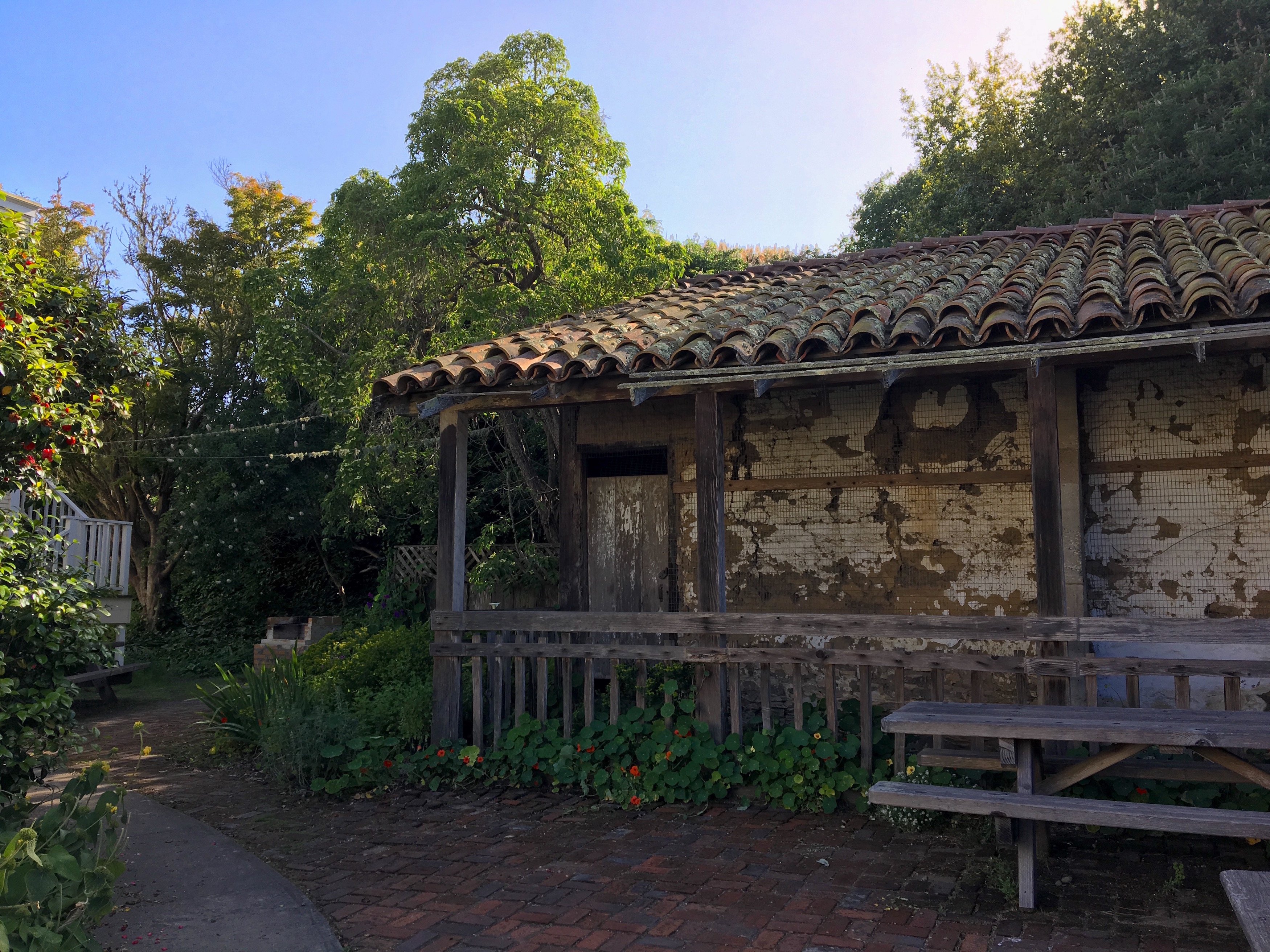
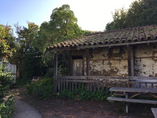
The Bolcoff Adobe at Wilder Ranch State Park was built around 1840 using materials (including the roof tiles) from the Santa Cruz Mission. Photo by Traci Hukill.
The Bolcoff Adobe
One of the most colorful citizens of early Santa Cruz County
was Jose Antonio Bolcoff, born Osip Volkov in Siberia in 1796. At the age of
19, Volkov deserted his Russian fur-trading ship when it anchored in the harbor
at Monterey. In short order he had won himself a place in the town’s Spanish
Californio society, working as an interpreter for the governor and taking a
Spanish name. Seven years later Bolcoff married the well-connected Maria
Candida Castro, the daughter of Joaquin Castro (the soldier who had settled in
Villa de Branciforte), and the couple moved to Villa de Branciforte. By 1833
Bolcoff was the alcalde, or mayor, of
the settlement.
The year 1839 was a big one for the Bolcoffs. Not only was Jose Bolcoff named administrator for Mission Santa Cruz—which had undergone secularization in 1834 and was being disassembled, piece by piece—but Maria Candida and her two younger sisters were given Rancho Refugio, a 12,000-acre land grant that includes what is now Wilder Ranch State Park. Jose and Maria Candida set up housekeeping at Rancho Refugio and built a home where the present-day parking lot is found. They also built the Bolcoff Adobe, believed to have been a farm building, using some of the beams and tiles from the Mission Santa Cruz.
By 1841, Jose Bolcoff’s name had mysteriously appeared on the Rancho Refugio grant, and the names of his wife‘s sisters had just as mysteriously disappeared. Decades later, in 1870, the U.S. Supreme Court ruled that the original grant had indeed been made to all three sisters and that Bolcoff had “suppressed or destroyed” the original and “fabricated” the new one. Read more about Wilder Ranch State Park.
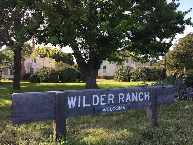
Wilder Ranch State Park is located 15 minutes north of Downtown Santa Cruz on Highway 1, at 1401 Coast Road, Santa Cruz. Parking is $10.
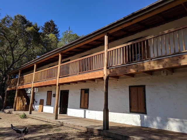
The Castro Adobe, thought to have been built in 1848 or 1849, is the only two-story adobe in Santa Cruz County. In 2002 it was acquired by the State of California and is now a state park. Friends of Santa Cruz State Parks photo.
Unlike most historic adobes in California, which are found in cities or towns, the Castro Adobe is in a rural area, gracefully situated on a hill overlooking the Pajaro Valley and Monterey Bay. The Adobe’s idyllic, relatively undeveloped location makes it easy for visitors to vividly imagine life there in 1849 when historians believe the two-story home was constructed by Juan Jose Castro, the son of Joaquin Castro and brother of the rightful owners of Rancho Refugio.
Castro family legend has it that the house was built with
$30,000 from the gold fields. We may never know if that’s true, but unlike the
Easterners and Midwesterners who had to first get to California before setting
out for Gold Country, the Californios were able to race up to the Motherlode as
soon as gold was discovered at Sutter’s Mill and collect the easy pickings. In
any event, once built, the Castro Adobe was a center of social activity, with
feasts and entertainments, including bull-and-bear fights in the yard (it was a
different time) and fandangos on the second floor.
After statehood in 1850, the Castro family was beset by
lawsuits and eventually had to sell the family home. It passed through many
hands, at one point being used as a barn. It was remodeled many times.
In the 1980s an adobe historian named Edna Kimbro bought the Castro Adobe, and, although the Loma Prieta Earthquake of 1989 almost destroyed it — and definitely rendered it uninhabitable — she worked tirelessly to have it purchased by the State of California to be repaired and turned into a state park emblematic of the Mexican Era in California. The State completed the purchase in 2002, and the Friends of Santa Cruz State Parks spearheaded a massive rehabilitation effort that began in 2009.
Today the Castro Adobe is the focal point of Rancho San Andres Castro Adobe State Historic Park. Fully restored and up to code, it features a wheelchair-accessible lift to the second floor, brand-new first- and second-floor verandas, extensive seismic retrofitting (which is not easy to do with historic earthen structures; the story will delight engineers types), and a functioning brasero, or traditional cooking range, that schoolchildren use for making tortillas on field trips to learn about the Californio era. Read more about the Castro Adobe.
Below are a few history-rich hikes in the Santa Cruz Mountains with stories to tell about loggers and environmentalists and other California dreamers who were drawn to these mountains, just as we are today. There are hikes in Big Basin that we can look forward to taking one day, and hikes in Nisene Marks and Fall Creek that are open and available now.
Scientists tell us that before 1800, about 4.5 million acres burned each year in California. Fire — both controlled burns set by indigenous people as a land management technique and wildfires that raced out of control — have shaped the state’s landscape for millennia. Many plants have evolved to release their seeds only when their pods are superheated, as happens in a wildfire. Redwood trees have tough fire-resistant outer bark that enables them to survive infernos that would incinerate other trees.
The CZU wildfire of August 2020 burned more than 85,000 acres in Santa Cruz and San Mateo counties, including a large percentage of Big Basin Redwoods State Park and parts of the Fall Creek Unit of Henry Cowell Redwoods State Park (as of May 2022, all trails at Fall Creek are open). Big Basin is closed until further notice, and parks lovers everywhere are feeling the loss. But these ecosystems evolved to survive wildfire. They’ll regenerate. They will come back healthier than we’ve ever seen them in our lifetimes. This is part of the cycle of life in the Golden State, a place bursting with natural beauty. It’s history in the making, and we will get to witness the regeneration of these forests.
Read on to plan your next historical hike in the Santa Cruz Mountains. Learn more about the resilience of redwood trees and the survival of Big Basin’s beloved Mother and Father of the Forest in Redwood Love.
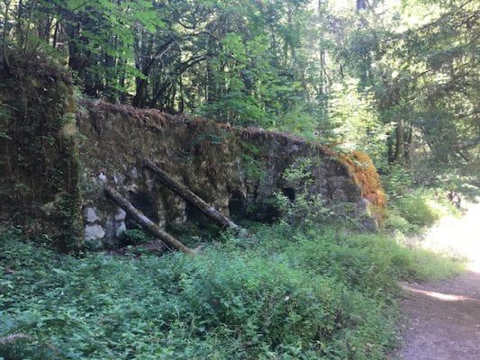
The lime kilns at Fall Creek furnished a crucial component of mortar during California’s turn-of-the-century building boom. Traci Hukill photo.
Lime Kilns and Barrel Mill at Fall Creek
Henry Cowell Redwoods State Park, Fall
Creek Unit
5.5
miles RT
Just west of the mountain town of Felton lies the Fall Creek Unit of Henry Cowell Redwoods State Park. Quieter than the main portion of the park, which has a campground, visitor center and a magnificent stand of old-growth redwood trees, Fall Creek consists of 20 miles of trail, very few old-growth redwoods, and no facilities—but its intriguing historical features are still intact and its trails pleasantly uncrowded.
In 1875 the IXL Lime Company of San Francisco purchased this
tract to produce lime for the mortar used in masonry buildings. California’s
population was booming, and a series of dramatic fires had caused wooden
structures to fall out of favor. The pressing need for mortar—and the redwood
trees of the Fall Creek watershed—fueled three kilns that ran 24/7 from 1875 to
1896 and produced 50,000 barrels of lime per year. Santa Cruz County’s lime
production accounted for a third of California’s supply and three-quarters of
San Francisco’s, but the business came at a cost: each of the three kilns
burned for three to four days, requiring 70 cords of wood—redwood—to produce
1,000 barrels of lime. The watershed was logged almost bare to fire the kilns
and make the barrels.
In 1900, lime magnate Henry Cowell purchased the lime works
and supplied much of San Francisco’s need following the 1906 earthquake, but
lime was soon displaced by cement, and the kilns closed in 1919.
Today the kilns are overgrown with moss, weeds and even
trees, but they retain a sort of grandeur. To get there, take the Bennett Creek
Trail from the parking lot on Felton Empire Road, then follow Fall Creek Trail
for about ¾ of a mile along a redwood-shaded path next to the creek. Cross the
footbridge and stay to the left, continuing along the South Fork of Fall Creek
until you get to the lime kilns. Look for the Blue Cliff a few hundred feet beyond
the kilns; it’s the source of the limestone.
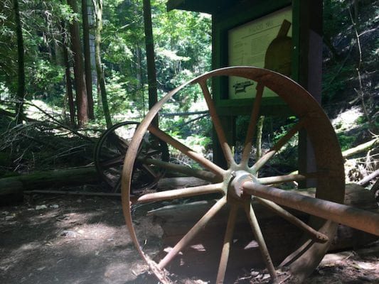
An interpretive panel and some rusted equipment are all that remain of the barrel mill site in Fall Creek. Traci Hukill photo.
To visit the barrel mill site built by Henry Cowell’s son
Samuel in 1912, follow the Cape Horn Trail at the Powder Magazine, just a few
hundred feet from the lime kilns, and take it to the Fall Creek Trail, then
proceed to the barrel mill site. This trail is not for the faint of heart; it
requires scrambling over and under logs and crossing Fall Creek via a jumble of
rocks and logs.
Return the way you came, unless you feel like taking a really big hike. In that case, continue
on Fall Creek Trail to the Big Ben Trail and turn left to make your way to the
park’s lone old growth redwood. Follow the signs back to the parking lot via Lost
Empire Trail (total mileage: 8+).
Note: Do not rely on the map on your phone here; many people get lost doing that. Instead, go to the main unit of Henry Cowell Redwoods State Park to pay the $10 entrance fee and receive a complimentary paper map.
The Fall Creek Unit
parking lot is ¾ of a mile west of Highway 9 on Felton Empire Road.
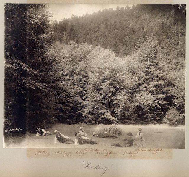
One of the campsites on the May 1900 Sempervirens Club excursion where the California state park system was born. Taking the photo is A.P. Hill, the group’s leader. Photo courtesy History San Jose.
Slippery Rock and Sempervirens Falls via Sequoia Trail (temporarily closed)
On May 18, 1900, a party of writers, scientists, artists and
citizens concerned about the rampant logging of redwoods in the Santa Cruz
Mountains camped between a waterfall and the base of a peculiar sloping rock
formation at the edge of the forest. That night they formed a plan. They would
call themselves the Sempervirens Club and dedicate themselves to saving the
mighty redwood trees from the saw. They passed a hat to fund their fledgling
operation: the take was $32.
Within two years the men and women of the Sempervirens Club had succeeded in saving 3800 acres, including a magnificent old-growth grove, and persuading the California legislature to purchase the tract as California’s first state park. The establishment of California Redwood Park, now known as Big Basin Redwoods State Park, didn’t just launch the state park system, it gave birth to the modern conservation movement in California. And it all started with a camping trip.
The Sequoia Trail, which makes a loop starting at park
headquarters, leads past the picturesque Sempervirens Falls, which remains much
as it was in 1900, and up the Slippery Rock, an outcropping of Miocene
sandstone (careful in wet weather!). You’ll notice the historical marker for
the Sempervirens Club campsite between the two landmarks.
The Sequoia Trail itself is one of the oldest in the park,
possibly used as early as 1875. The section between Opal Creek and Slippery
Rock, once known as the Trail Beautiful, was built in 1895. Part of this
section, which comes right up to Highway 236, dips down into a really gorgeous
ravine with some spectacular old-growth specimens on its way down to Opal
Creek. Note the cloudy turquoise-and-amber waters of this creek, its color due
to tannins in the water from the redwoods.
If you haven’t already, you can walk the half-mile Redwood
Trail with its enormous old-growth trees for a vivid illustration of what the
Sempervirens Club accomplished.
Big Basin Redwoods
State Park, 21600 Big Basin Way, Boulder Creek. 831.338.8860. $10 vehicle use
fee.
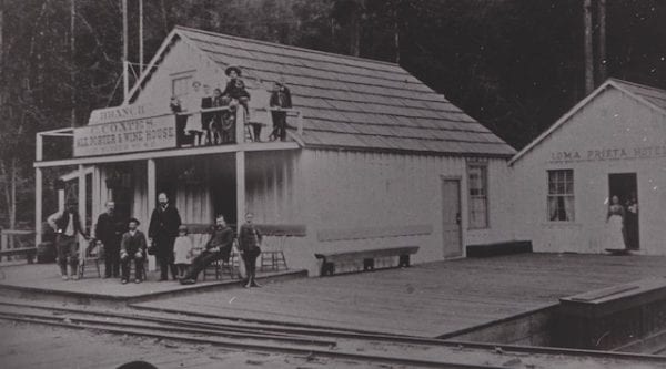
The town of Loma Prieta in its heyday, with hotel and saloon ready to receive guests. The town vanished when the logging stopped. Photo courtesy Santa Cruz Museum of Art and History.
Hoffman’s Historic Site via Loma Prieta Grade Trail
4 miles RT from Porter
Picnic Area (with option to extend to Maple Falls for a 7.7-mile RT). Please
note that Porter Picnic Area is closed in winter.
Though logging in Santa Cruz County officially started
booming with the Gold Rush, nobody even considered trying to log steep, narrow
Aptos Canyon until the early 1880s, when the mighty Southern Pacific Railroad Corporation
stepped in to fund the Loma Prieta Logging Company. By 1890 Chinese laborers
had laid 7.5 miles of standard gauge track alongside Aptos Creek so trains
could pull huge redwood logs from the depths of the canyon to the mill and on
to market. At one point the Loma Prieta Sawmill was cutting 70,000 board feet of
virgin redwood a day, and the town of Loma Prieta was home to 300 citizens, a
hotel, a saloon, a Wells Fargo office and a school district.
Once the trees were gone, the town and the
sawmill shut down, and eventually the tracks were pulled up to create what is
now Aptos Creek Fire Road, the main arterial through a beautiful second-growth
redwood forest and the largest state park in the county.
This hike to the site of an old logging
camp that operated from 1918 to 1921 starts at the Porter Family Picnic Area
(closed in winter, but you can park at George’s Picnic Area year-round and walk
the mile to Porter’s). A quarter mile from Porter’s, Loma Prieta Grade Trail
leads off to the left up a gentle incline. The trail follows a narrow-gauge
railroad built by the Loma Prieta Lumber Company for its last foray into the watershed,
to a place called Big Tree Gulch famed for the 15- to 18-foot diameter redwoods
that grew there. (It’s now called Big Stump Gulch.) Reportedly the best-preserved
narrow gauge railbed in the county, the trail hugs the side of the Bridge Creek
canyon as it climbs ever upward. One dizzying stretch features an 80-foot
dropoff to the creek below. Railroad ties are visible occasionally along the
entire route.
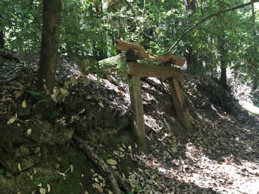
This structure once held a water tank for the steam locomotives bringing out the last of the big redwoods in the Aptos Creek watershed. Traci Hukill photo.
Note the A-frame structure about
halfway to Hoffman’s Historic Site; it once supported a water tank for the
locomotives. Keep an eye out for a stand of eucalyptus where the logging
company had a reforestation experiment until officials realized that eucalyptus,
though fast-growing, makes poor lumber.
Little remains of Hoffman’s Historic
Site, which once had a 120-foot-long bunkhouse and a dozen buildings, but it’s
a nice place for a snack. Turn around and go back the way you came, or else
continue on through Big Stump Gulch to the Bridge Creek Trail and turn left to
get to 30-foot Maple Falls (slippery going in winter). Return via Bridge Creek Trail,
which rejoins Loma Prieta Grade Trail.
Nature has almost entirely erased any sign of logging in Nisene Marks. Traci Hukill photo.
Whether you go to Maple Falls or not,
take the short Mill Pond Trail cutoff on your return (left at the Porter House
Site) to see the old Loma Prieta town and mill sites.
Forest
of Nisene Marks State Park, Aptos Creek Road, off Soquel and State Park Drive,
Aptos. 831.763.7062. Entrance fee: $8.
The morning of January 6, 1926 dawned in Santa
Cruz County like any other day of that heady time. Nationally, the stock market
was picking up steam on its way to the wildest ride in history. Sears, Roebuck
& Co. had just opened its first retail store, and booksellers were hawking
a critically acclaimed new Jazz Age novel called The Great Gatsby. Down
the coast in San Luis Obispo, the nation’s first “motorist’s hotel” had just
opened its doors on the long shot that Americans would take to vacationing in
their automobiles. And across the nation, the prohibition on alcohol was
entering its seventh year.
That day, 22 federal agents swarmed nine locations in Santa Cruz County from the coast all the way up to Boulder Creek, seizing gin, whisky and the largest quantity of wine confiscated in the county since the start of Prohibition — some 36,000 gallons worth an estimated $100,000. If anyone was naïve enough to doubt that bootlegging, rum running and moonshining were alive and well in Santa Cruz County during those supposedly dry years, the big raid put those doubts to rest.
Rum Runners on The Bay
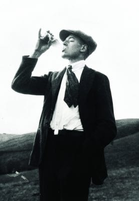
From the earliest days of Prohibition, the citizens of Santa Cruz County indicated that they were not universally interested in abstaining from alcohol. Though the National Prohibition Act didn’t officially take effect until 1920, Aptos declared itself dry in 1912 — and one colorful saloonkeeper wasn’t having any of it. Patrick Walsh, the 83-year-old proprietor of the Live Oak House in downtown Aptos (it stood roughly across Soquel Drive from the Bay View Hotel), ignored repeated orders to close down and eventually landed in jail in nearby Santa Cruz, where, local historian John Hibble tells us, he was allowed to serve out his sentence in an unlocked cell, playing cards and drinking whisky with his friends.
A stylish Stephen Martinelli Jr. enjoys a refreshing beverage. Photo courtesy S. Martinelli Co.
Once Prohibition became the law of the land, it
wasn’t long before West Coast entrepreneurs with flexible mores began smuggling
Scotch and whisky from Canada into the United States via California beaches. In
time they developed a sophisticated system of transport that involved large
ships sitting 12 or more miles off the coast (in international waters, beyond
the reach of the Coast Guard) while powerful speedboats capable of easily
outrunning the Coast Guard’s utilitarian vessels shuttled to and from the big
boats with shipments of up to 500 cases at a time.
The remote, sandy shores of southern Santa Cruz County — in particular the string of beaches from New Brighton to La Selva, then known as Rob Roy — proved an excellent place to unload alcohol bound for San Francisco and the rest of Northern California. Here were friendly locals who would help unload the rum runners’ boats in exchange for a couple of bottles, cabins on neighboring ranches that could be used as stash houses, and law enforcement officials who could be paid to look the other way. Even the Cement Ship was used to store contraband.
To frustrated federal agents, it might have seemed like the whole town was in cahoots with the outlaws. Malio Stagnaro, the “Mayor of the Santa Cruz Wharf” until his death in 1985, recalled with amusement selling fuel to the rum runners on one side of the Santa Cruz Wharf and the Coast Guard on the other. According to his telling, the smugglers became downright brazen. While most liquor was delivered under cover of night, on one occasion they unloaded a shipment right onto the wharf in the middle of a Sunday afternoon, claiming it was salt.
Moonshiners and Monkeyshines
While the big-time rum runners did their thing, the small-time local moonshiners and bootleggers did theirs. Stills popped up all over the Santa Cruz Mountains to take advantage of good water sources and even better hiding places.
Paul Johnston, an Aptos businessman, property
owner and mail carrier, remembered finding a 3-foot piece of copper coil lying
in the middle of the road one day during his rounds. It turned out a Ben Lomond
still had been warned of a bust and hastily relocated to Trout Gulch in the
Aptos hills, losing a piece of equipment in the process. Johnston told a friend
who had a brother in the Prohibition Service what he’d found, and the operation
was stung not long after.
Moonshiners often used sugar to make nearly pure alcohol, selling it in 5-gallon cans to bootleggers who then added water along with burnt sugar for coloring or maybe some juniper berries for a fine bathtub gin effect. The resulting concoctions found their way into establishments all over the county: at the Garibaldi Villa Hotel on Front Street in Santa Cruz, next to the San Lorenzo River; at the Swiss Hotel on Water Street; at the lavish Hawaiian Gardens in Capitola, done up in the extravagant Orientalist style of the day with a lamplit waterfall and pool where guests could stash their bottles; and in countless other restaurants, hotels and dance halls that operated more or less in the open, paying the local constabulary for protection but resigned to the occasional bust by police “so it would look right,” as Stagnaro put it.
Days of Wine and Hijinks
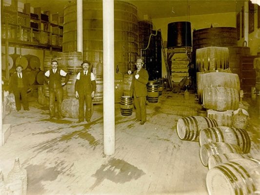
For the Italians of Santa Cruz County, Prohibition must have seemed crazy. They drank wine at every meal, gave it in diluted form to their kids, and generally considered wine drinking to be part of a civilized life. After Prohibition, families were allowed to make up to 200 gallons of wine — four barrels — a year for personal consumption. Some enterprising families decided to go above and beyond that. Among those were the Bargettos.
Filippo Bargetto (second from left) at the South Montebello Vineyard and Wine Company in San Francisco, circa 1915. To his left is his uncle, Barba Giovanin. Photo courtesy of Bargetto Winery.
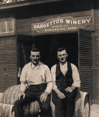
Filippo and Giovanni Bargetto had originally
come from the Piedmont and worked as winemakers in the Bay Area until the
looming threat of Prohibition forced a change of plans.By the mid-1920s, they
and their wives Francesca and Ernestina, sisters from the Bargettos’ hometown
in Italy, were farming fruits and vegetables in Soquel. Under financial
pressure, and unable to help noticing a brisk trade in red wine all over Santa
Cruz County, the brothers made their first batch of bootleg wine in 1926—six
barrels. It sold in a trice. As Gianni’s grandson John E. Bargetto writes in
the highly entertaining book The Great Prohibition Caper: Bootlegging in
Soquel, the 1927 harvest of Zinfandel and Charbono grapes was irresistibly
good, so the brothers decided to ramp up production that year to 22 barrels.
It was in the early months of 1928, as the young wine was slowly maturing in its oaken beds, that the Feds arrived. The scowling agents went away that day with a promise to return and what seemed like an end to the Bargettos’ dreams of winemaking. Things were looking grim until Johnny, as he now called himself, hit upon a scheme to save the wine. We won’t spoil the ending, so you’ll have to read the book for the whole story, but suffice it to say that with the help of a hand pump, friends with storage space and some ingenuity, the year’s production was saved. Today Bargetto Winery in Soquel proudly advertises the year of its establishment as 1933 — the year Prohibition ended. (So maybe they had a running start. Who’s counting?)
Fillipo and Gianni Bargetto, as pictured on Bargetto Winery’s La Vita label.
A Classic is Born
Prohibition eventually proved beneficial for the
Bargettos, but it was an almost immediate boon for the Martinellis. A Swiss
farmer’s son who had learned the art of making Champagne in France before
coming to California in search of gold, Stefano Martinelli began making sodas—loganberry,
sarsaparilla and ginger ale—in 1866 in his big brother’s shed in the Pajaro
Valley. But he really hit the big time with the perfection of his
Champagne-style apple cider, a beverage with 7.5% to 10% alcohol by volume. In
1890 Martinelli’s sparkling hard cider won the gold medal at the California
State Fair. Its popularity soared, and soon Martinelli’s cider could be found
all over California and in neighboring states.
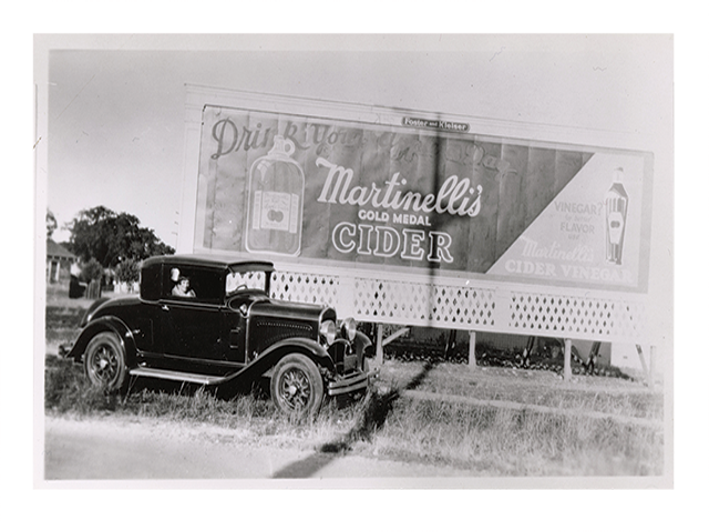
Then, in 1915, Arizona — one of S. Martinelli & Co.’s biggest markets — banned alcohol. Suddenly the future wavered.
Workers with the raw materials that make up Martinelli’s famous sparkling apple cider. The family credited a blend of Watsonville-grown apples, including the sweet Newtown Pippin, with the success of their cider. Photo courtesy S. Martinelli & Co.
Martinelli’s son Stephen Jr., then studying at
Berkeley, immediately started working with his professor on a pasteurization
method to produce a shelf-stable fruit juice that could replace the alcoholic
product. In the fall of 1917, Martinelli’s non-alcoholic sparkling apple juice
reached the market. As the award-winning coffee table book S. Martinelli
& Company: Celebrating 150 Years explains, uptake was slow at first,
but once Prohibition hit, Martinelli’s became a festive and delicious stand-in
for beer and wine, served in restaurants, elegant hotels and the fine dining
cars of the Southern Pacific Railroad, and even featured in the movies. It
became more popular during the Depression when Martinelli’s started marketing
it in apple-shaped glass bottles, along with the popular “Drink Your Apple A
Day” campaign.
By 1944 Martinelli’s was producing 600,000
gallons of sparkling non-alcoholic cider a year, 50 times the amount of hard
cider it had been bottling before Prohibition. Today Martinelli’s remains the
go-to non-alcoholic beverage for celebrating special occasions, on hand during
holidays and at dinners with friends.
And it wouldn’t have happened without that odd
13-year experiment in forced abstinence.
How the first inhabitants of northern Monterey Bay lived, and how their descendants are keeping tradition alive.
Long before European-style towns sprang up along the coastal plains and valleys of the Santa Cruz Mountains, another people lived here. Season by season they followed the rhythms of nature just as their ancestors had, treading well-worn paths between their traditional villages on the plain and their gathering grounds in the foothills and mountains.
Banded together in “tribelets” of several hundred people, their names ring familiar today: the Aptos of the southern Santa Cruz County coast; the Sokel of the inland valley now known as Soquel; the Sayanta of the San Lorenzo Valley, later called Rancho Zayante; the Cotoni (cho-toni) of Davenport, gateway to the Cotoni-Coast Dairies National Monument.
These tribelets, who shared a way of life but considered themselves quite separate from their neighbors (they spoke very different dialects), are part of a culturally distinct group of indigenous people called the Ohlone. In the mid-1700s, before European contact, the Ohlone numbered some 10,000 people inhabiting a vast swath of land stretching from San Francisco south to Big Sur and extending roughly 50 miles inland. They had already been here for millennia when the first Spaniards showed up; some of their shell mounds are 4,000 years old.
An Ohlone village was a grouping of domed structures made
from willow poles with bunches of tule rushes for walls and a roof. Each house
was between 6 and 20 feet in diameter, depending on the family’s needs, and a
larger structure often stood in the village center for dances and gatherings. When
a hut’s tule rushes got too soggy or became infested with insects, it was
simply abandoned and a new one built.
Though villages were home base, people traveled to the hills and mountains to gather the all-important acorns each fall and to harvest grass and wildflower seeds in the spring. There were other harvests to attend to as well: hazelnuts, blackberries, gooseberries and huckleberries in summer, salmon runs and shellfish in the winter, the occasional windfall of a beached whale, and year-round hunting of waterfowl, rabbit and deer. But nothing came close to the acorns in importance.
Acorns from black oaks and tanoaks were the most delicious,
those from live oaks the most widely available, those from valley oaks the
hardest to split. Whatever the source, their shells needed to be cracked and
their meat ground in a laborious process undertaken by the women. After that
the meal had to be leached in up to 10 rinses of cold water until the tannic
acid had washed out. Only then was it time to cook. If soup was on the menu, the
women filled a specially woven watertight basket with water and meal and
dropped hot rocks in to boil the soup, moving the rocks around so the basket
wouldn’t burn. Sometimes they baked the meal into loaves of bread. Rich in
protein, carbohydrates and fat, acorn meal formed a nutritious dietary base
complemented by other foods as the season allowed.
When they weren’t gathering food or cooking, Ohlone women wove
fine baskets for storage, cooking and eating, decorating them with shells and feathers.
The men made boats for fishing from the same tule rushes that kept their homes
warm and dry, bundling them into watertight, lightweight and ultimately
disposable vessels that they plied with skill across the marshes and rivers. During
their free time Ohlone of both genders played betting games, adorned themselves
for dances, kept up on village gossip and taught their children how to be
upstanding Ohlone citizens (put the tribelet’s needs before your own and take
care of your relatives).
By all accounts the Ohlone—though they intermarried and traded with nearby tribelets—lived in a state of constant low-level tension with their neighbors, alert to territorial incursions or insults. But they were extremely hospitable to visitors, including the Spaniards. They can even be credited with the Spaniards’ successful “discovery” of San Francisco Bay, since the Quiroste tribelet of present-day San Mateo County nursed the lost and sickly men of the Portola expedition back to health in 1769, enabling them to continue on their journey to the Bay.
European contact, as is well documented, was not nearly as
kind in return to the Ohlone people. They lost their traditions and lifeways at
the missions, and enormous numbers of them perished from European diseases like
smallpox and measles. The ones who survived the Mission era, which ended in
1834, blended into the dominant culture to avoid discrimination, intermarrying
with Mexicans or Europeans, or else came together in impoverished, low-profile
communities with other Ohlone. Their culture went underground, and the last
native speaker died in 1935.
Today there is more hope than there was in those bleak decades.
The Amah Mutsun Tribal Band, to which descendants of the Santa Cruz area Ohlone
belong, is slowly reestablishing a presence in its ancestral homeland. Much of
this has to do with the historic Ohlone use of fire to shape the landscape,
burn off underbrush and prevent catastrophic wildfire—a traditional approach to
land stewardship that is gaining serious attention from scientists and
policymakers in wildfire-prone California.
Though it might seem as if the Ohlone lived passively off the fruits of a magnificent, benevolent wilderness, the truth that they were more like gardeners. They routinely burned grasslands—an important source of food from seeds—to stimulate reseeding the following spring. The tender young shoots attracted deer, another food source, and the regular burns kept the dense, highly flammable chaparral from taking over the meadows and posing fire danger. It seems the technique even allowed different plants to flourish than we see today; early Spaniard visitors report having seen hazelnut trees—rare in central California—in the middle of scorched meadows in the Quiroste territory.
In the spirit of learning more about these techniques, the Amah
Mutsun have partnered with California State Parks archeologists and the
University of California to establish the Quiroste Valley Cultural Preserve, a
225-acre parcel inside Ano Nuevo State Park, where tribal members and
scientists are working to restore the land to its pre-contact state through
pruning and controlled burns.
Just up the road from the city of Santa Cruz lies the
Cotoni-Coast Dairies National Monument, established in 2017 as one of President
Obama’s final acts in office. The Bureau of Land Management, which manages the
land, has made an agreement with the Amah Mutsun to allow them access to the
land to practice “Traditional Ecological Knowledge,” including ancient land stewardship
techniques.
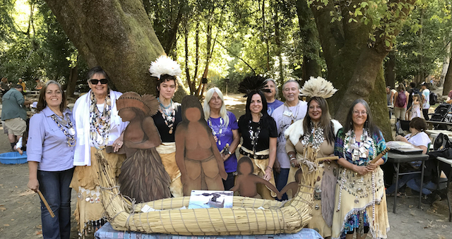
Even the language is making a comeback. Members of the Amah Mutsun are now learning their ancestral tongue; the effort got a boost from scholarship undertaken by linguist Marc Okrand in the 1970s. (Fun fact: Okrand created the fictional Klingon language for the Star Trek franchise, drawing upon his knowledge of Mutsun grammar to do so.) Meanwhile, dedicated individuals keep the other Ohlone arts—basketmaking, dancing and music—alive through practice and events like the annual Ohlone Day, held every September at Henry Cowell Redwoods State Park.
Though the world of the Ohlone has changed dramatically, it
is clear that their descendants are finding a way not just to be part of the
new world but to help lead it toward a better, maybe wiser, future.
To learn about indigenous people’s housing during the Mission Era, read our blog post about Mission Santa Cruz.
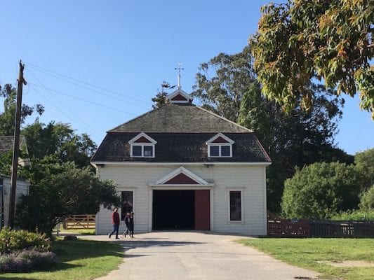
People love Wilder Ranch State Park. Hikers and mountain bikers come from all over to explore its 34 miles of trail winding through oak-crowned meadows and redwood ravines and to gape at its stupendous views of Monterey Bay. But many visitors also come to savor the gentler charms of the old farm complex, a tidy arrangement of whitewashed barns and restored old homes sheltered in a valley out of the reach of the brisk ocean breeze. Here goats, chickens and draft horses go about their peaceful daily business, the antique tractors snooze in their garage and time putters along like a Model T on Highway 1, cheerfully oblivious to the line of modern conveniences piled up behind and itching to take over.
A Place for Happy Cows
Long before Europeans arrived, Wilder Ranch was home to tribes of Ohlone-speaking indigenous people who migrated seasonally between the backcountry and the shore. During the Mission years (1790s through the 1830s), Wilder Ranch was part of a huge swath of land between Santa Cruz and Año Nuevo to the north where the sheep and cattle of the Santa Cruz Mission grazed. If you look up from the Wilder Ranch State Park parking lot toward the mountains, you can see benchlands that look like happy cow country—away from the direct chill of the coast but not too hot, either. The Visitor Center has great information on these periods.
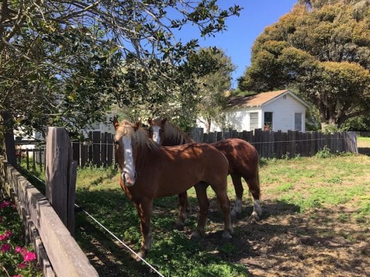
Draft horses living the dream in the pasture next to the Visitor Center. On special celebration days they pull wagons for hay rides.
To reach the cultural preserve, walk down the short (300 yards) stretch of asphalt leading from the parking lot to the old Coast Road, itself a piece of history: this is the predecessor to Highway 1. Ranch tours happen every weekend day at 1pm, and special event days feature homemade ice cream, games, hay rides, tours and living history demonstrations of skills like blacksmithing.
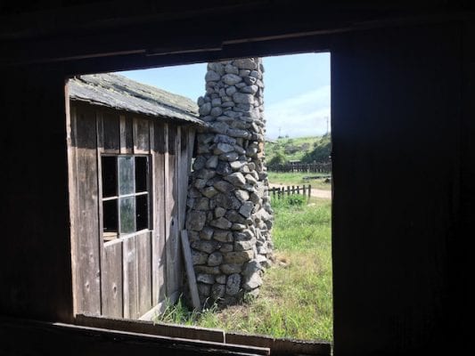
The Bolcoff Adobe, built around 1840, is the oldest building in the Wilder Ranch complex. Its roof tiles were transported from the old Santa Cruz Mission buildings as they were parceled out after secularization.
The oldest building in the cultural preserve was built by
Wilder’s first dairy operators—but that’s not really what the Bolcoffs were
known for. Jose Antonio Bolcoff was actually born Osip Volkov in Siberia; he’d
jumped ship in Monterey in 1815 and quickly established himself in the upper echelons
of Mexican Californio society, even winning the hand of Maria Candida Castro,
daughter of a prominent settler. He and Maria built the Bolcoff Adobe—probably
used as a dairy barn or work building on the farm—and a house (located where
the parking lot is now) where their 17 children were born.
Fun fact: the tiles on the roof of the Bolcoff Adobe are a physical record of the indigenous laborers at the Santa Cruz Mission. Workers formed the tiles by molding the still-wet clay over their thighs, then allowing the tiles to dry in that shape. Bolcoff, who oversaw one phase of the Mission’s secularization, had the tiles brought to his new ranch.
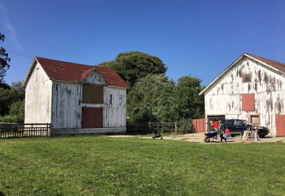
The granary, left, and the dairy barn at Wilder Ranch are no longer in use, but they make a nice staging area for the volunteers who come to feed the goats, horses and chickens that live at the ranch.
Serious dairying didn’t start at the farm until the 1850s. California’s
population exploded as Easterners and Midwesterners rushed west in search of
gold, bringing with them certain expectations and appetites—including a demand
for milk and everything made from it. Dairies popped up all over the hinterland
surrounding San Francisco, and those the farthest out turned to items like
butter and cheese that, unlike fresh milk, could make the trip to market without
spoiling.
Into this opportunity stepped one Moses Meder, an
enterprising lumberman who had arrived in San Francisco on the first Mormon
ship to drop anchor in California. Meder became something of a one-man bank in
Santa Cruz, holding people’s savings for them, extending credit and buying
lands. (He also had philanthropic impulses and perhaps some sympathy for fellow
religious minorities: he donated some of his land in Santa Cruz for a Jewish
cemetery under the condition that he and his family be welcome to spend
eternity there also.) Meder took possession of the farm in a foreclosure and
set to dairying in earnest in 1854, expanding on the Bolcoff’s operation by
building the dairy barn and a creamery that has since burned down.
Meder’s butter fetched nearly $1 per pound in San
Francisco—a huge sum at the time. The plain but sturdy and prosperous-looking Meder
House, pictured below, was his home.
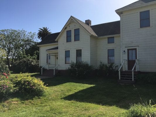
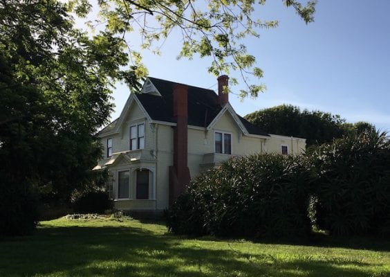
The home that butter built: Moses Meder built the front half (at left) of this Gothic revival farmhouse in the 1850s.
Engine of Innovation
Wilder Ranch as we know it today really came into its own in
1885, when a Connecticut transplant named Deloss D. Wilder took sole possession
of the farm complex and gave his innovative instincts free rein. The resulting
prosperity sustained the Wilder clan for five generations. With a herd of 300
Durham, Jersey and Ayrshire milking cows, Wilder Creamery continued the farm’s proud
tradition of making famous butter, and all the while Deloss Wilder was figuring
out ways to make production more efficient and profitable.
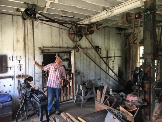
Docent Cliff Bernie runs the Pelton water wheel in the machine shop, which operates the lathe next to him via a system of pulleys. A drill press is mounted on the post in the right of the frame.
In 1886, Wilder bought two Pelton water wheels. A
contraption invented in Gold Country, the Pelton wheel was uniquely suited to
arid California’s smaller waterways; it ran on the force of the moving water
rather than its volume, so as long as you could find a small creek or stream
that was moving quickly, you could extract energy from it using the Pelton
wheel. Wilder built a reservoir on a hilltop some 9,000 feet from the farm
complex and capitalized on the 216-foot elevation drop with an 8-inch pipe full
of rushing water that fed the wheels, producing 100 horsepower.
Tours take place every Saturday and Sunday at 1pm, and
include a demonstration of a still-functioning Pelton wheel at work in the
machine shop. It ran a lathe, sander, drill press and even a coffee grinder (a
necessity when you’re up at 3:30am to milk cows! Other Pelton wheels around the
property, positioned along a network of pipes, ran a table saw, the cream
separator and a dynamo that lit up the place with electric lights long before
any other farm in the county had them. (Many farms throughout the United States
lacked electricity until President Roosevelt’s Rural Electrification
Administration brought it to them 50 years later.)
With these kinds of innovations in its past, it’s no wonder
that Wilder Ranch State Park was nearly chosen to be the home of the California
Dairy Museum. From 1976 to 1981, the state parks department studied the idea,
but eventually decided against it.
The Victorian at Wilder Ranch was built in 1897 to convince young newlyweds Melvin and Lettie Wilder to come home and build a life on the farm. It had electric lights and indoor plumbing (hot water included).
In 1897 Deloss Wilder convinced his son Melvin and his new
bride Lettie to come make a life on the family farm. Melvin was a Stanford
graduate in electrical engineering with a bright future, so his father had to
come up with something to lure him back. He did: the beautiful Victorian that
stands in the cultural preserve today. It had electricity, hot running water, redwood
cabinetry throughout painted to look like oak, and an icebox kept cool by ice
packed in sawdust and brought in from Truckee, 250 miles away.
The horse barn, built at the turn of the century, has stalls for 18 horses. Except for fresh paint, it’s in its original condition.
Melvin and Lettie moved in and continued Wilder’s tradition
of firsts: first gas-powered automobile in Santa Cruz County (a 1903 Knox),
first female truck driver in the county (Melvin and Lettie’s daughter Ethel),
almost certainly the first and probably only earbud-like device for listening
to wax recordings. (You can see a photo on the tour of delighted dinner party
guests sitting in the Victorian’s parlor listening through individual wires to
the phonograph.
The cowboy cabin next to the horse arena must have been the scene of some fun parties—Wilder Ranch was known to cowboys on the rodeo circuit as a good place to practice their skills.
In 1937 the economics of dairying changed, and the Wilders
turned to beef cattle ranching. The horse arena and rodeo grounds, which you
can see if you follow the road through the complex and through the highway
underpass, were known to cowboys on the rodeo circuit for lively practice
sessions that went on into the night with gas lights to illuminate the arena.
Antique farm implements are lined up along the trail that passes by the horse arena. To get there, follow the main road through the complex and take the underpass beneath Highway 1, then cross the cattle guard.
But those economics changed, too, and in 1969 the property
taxes outstripped the ranch’s profits. It was time to sell. In 1974 the State Department
of Parks and Recreation purchased the property.
Lucky us. Thanks to
that move, at Wilder Ranch you can step away from it all for a little while and
get a glimpse of life back when you could buy a few cows, build a house in the
country and make a living on a different kind of California gold.
Wilder Ranch State Park is located 15 minutes north of Downtown Santa Cruz on Highway 1, at 1401 Coast Road. Parking is $10. Ranch tours are every Saturday and Sunday at 1pm; for other activities, including the Independence Day and Heritage Harvest festivals, see the Wilder Ranch State Park website.
An equestrian and her father head through the cultural complex toward the Wilder Ranch backcountry.
Overlooking downtown Santa Cruz from a quiet redwood-shaded bluff lies a hidden historical treasure and an enchanting starting point for a journey back in time. Santa Cruz Mission State Historic Park is a one-acre island of tranquility with a spectacular view and a colorful story that begins more than 200 years ago. Its main feature, a long adobe building constructed in 1822 and 1824 as housing is all that remains of the Mission Santa Cruz, the 12th in a string of 21 Spanish missions established in California.
Like all the other missions, Mission Santa Cruz was founded by Franciscan priests eager to establish a presence in California. The location for their 12th mission was chosen because it would allow them access to the coastal tribes that had remained out of the reach of the prosperous Mission Santa Clara, isolated as they were by the steep, thickly forested Santa Cruz Mountains. On August 28, 1791, Father Fermin Lasuén founded Misión la Exaltacion de la Santa Cruz near the mouth of the San Lorenzo River. It flooded the first winter, and in 1793 the mission was reestablished on a bluff overlooking the river. The new site had a stream (it ran down what is now School Street, right in front of the park) and a pleasant view of Monterey Bay.
The young mission experienced great success for a few years. By 1796 it was home to 523 neophytes (the term for baptized indigenous people) and a church made out of adobe measuring 112 feet long by 29 feet wide—the widest of any original mission, thanks to the availability of huge redwood timbers to serve as reinforcing beams. It was producing wheat, barley, corn and even chickpeas and lentils. Even the modest gifts of livestock donated by neighboring missions at its founding—Santa Clara had sent 40 cows, Carmel had given seven mules and San Francisco had dispatched 60 sheep and 10 rams—were flourishing as if divinely favored: in 1797 Mission Santa Cruz recorded 710 head of cattle, 1,500 sheep, 500 mares with foals and 50 mules.
Mission Santa Cruz was eventually home to 32 buildings, including the Mission Adobe that stands today. Inside the Mission Adobe’s cool, dark interior, insulated by walls three feet thick, rooms interpret the lifeways of the Ohlone and Yokuts people who lived at the mission, and a diorama shows the mission complex as it was in 1830, when a cathedral, convent, soldiers’ barracks and twin dormitories were spread across the bluff and the Mission gardens grew plenty of watermelons, squashes, walnuts, olives and peaches.
In 1834 Mission Santa Cruz was secularized and the last natives to inhabit the Mission Adobe, Isidro Labrodo and Petra Mifro, sold their shares in 1848. From that point on the Mission Adobe was inhabited continuously by the Rodriguez family (on the eastern side) and the Armas and then Neary families (on the west side). The Mission Adobe is one of just four historic adobes left in Santa Cruz County; the others are the Castro Adobe, the Bolcoff Adobe at Wilder Ranch State Park, and the privately owned (and still inhabited) Branciforte Adobe in East Santa Cruz.
The dense neighborhood atop the present-day bluff has erased nearly every sign of the mission complex that once thrived there. The Holy Cross Catholic Church stands on the site of the original adobe church, which collapsed in an earthquake in 1857 despite its five-foot-thick walls and stone foundation. On the corner of School and Emmett streets, just steps from the Santa Cruz Mission State Historic Park, stands the Reliquary, built as a half-scale replica of the original mission church. Many visitors mistakenly believe this is the original mission, but it’s not. It is interesting, though: among other things, it contains Father Junipero Serra’s vestments.
Today the Mission Adobe is open five days a week (Thursday-Monday) year-round for self-guided tours and picnicking under the massive avocado tree (possibly the second-oldest in California!) or on the sunny patio. Grab a sack lunch downtown and climb the beautiful mosaic staircase leading up from Mission Street (the entrance is found between Center and Emmett streets; staircase is closed on weekdays during the school year). Don’t forget to stop by the gift shop to see old photos of the adobe through the years. On weekends the park offers living history demonstrations and family activities, and on special summer evenings everyone can gather around an Old Fashioned Campfire for music and fresh tortillas made the traditional way, on the comal.
The adobe’s courtyard bursts into life each September with
the wildly popular Mole and Mariachi Festival, a riot of colorful costumes, music,
food and dancing. The one-day festival, hosted by Friends of Santa Cruz State
Parks, raises money for the park’s year-round educational programs, which are
available to all at no cost.
Santa Cruz Mission
State Historic Park, 144 School St, Santa Cruz. (831) 425-5849. Open Monday, Thursday, Friday and Saturday
10am-4pm and Sunday noon-4pm. Entrance is free.